A Neighbourhood Walk for Reading a Proposed Change
A neighbourhood walk for reading a proposed change helps you spot routes, entrances and shared spaces, then ask better questions of the formal plans.
The common mistake when a local change is proposed is to judge it from a headline, a boundary line or a view through the car window. That can leave out the everyday routes and shared places most affected by it. A neighbourhood walk for reading a proposed change helps you notice what the formal plans may not make obvious, while keeping clear that observation is not a substitute for the documents, decision process or professional advice.
Take a notebook, a phone for photographs if appropriate, and a copy of the published plan. Choose a route that passes the proposal’s edges and the places people reach from them. The aim is not to decide whether the change is good or bad before you have the facts. It is to identify what to check, and to make your questions precise.
What can a walk tell you that a plan cannot?
A plan can show a proposed building, road alteration, service or public-space change within a marked boundary. Walking helps you see how that boundary meets the surroundings: where people approach, which paths already carry local movement, and what sits beside the site. Treat those observations as prompts for follow-up, not proof of what the proposal will do.
Keep three things separate in your notes: what you directly observe, what the published material says, and what you still do not know. “A narrow pavement meets the site entrance” is an observation. “The entrance will cause congestion” is a prediction that needs more evidence. That distinction makes your account fairer and more useful.
How should you choose and walk the route?
Start at a recognisable public point, such as a bus stop, library or junction. Walk past the proposal from more than one direction, then include nearby destinations and shared spaces that may connect to it. Avoid entering private property or approaching people to photograph them. If a location is inaccessible, note that rather than guessing what it is like.
Use the same route once at a time when local activity is visible, if practical. A school run, market day or shift change may reveal a different pattern from a quiet afternoon. Record when you went and what conditions might have shaped what you saw. One walk is a snapshot, not a complete account of a neighbourhood.
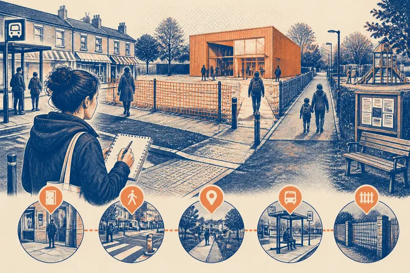
Imagine a council is considering a new community building on an unused plot beside a row of shops. You begin at the bus stop, walk along the shopfronts, pass the proposed entrance and continue to a nearby play area. You notice that people already cross the plot’s frontage on the way between the stop and the play area, and that the side street has no obvious place to wait. You write these as observations, then check the plans for pedestrian access and the application material for any assessment of movement. The result is not a verdict on the building; it is a focused question about how the entrance and existing route are meant to work together.
What should you note at entrances and everyday routes?
Look at each likely entrance from the public route. Is it visible from the pavement? Does it face a street, a path, a car park or a shared boundary? Note crossings, gates, steps, dropped kerbs, lighting and places where a person might have to pause. Do not infer accessibility from appearance alone; plans and accessibility information may answer details that a walk cannot.
Trace ordinary journeys rather than following only the proposal’s perimeter. A route to a shop, bus stop, school, clinic or riverside path may pass close to the site even if it is not labelled as an official access route. Write down where paths meet, where people wait, and where the route changes surface or direction. A walking route is like a thread through several rooms: a change in one place can matter because of what it connects to.
- Entrances: Record the visible location and direction each one faces; check the plan for access arrangements.
- Crossings: Note where people cross and what traffic, kerbs or sight lines are present; ask whether the proposal changes that connection.
- Everyday routes: Mark paths between local destinations; compare them with routes shown in the published material.
- Waiting places: Note bus stops, benches, queues or sheltered edges; ask whether these are within the proposal’s scope.
- Boundaries: Record fences, walls, planting or changes in level; check whether the documents explain what may change.
Which shared spaces deserve a closer look?
Include spaces that people use without needing to own or book them: a small green, a pavement corner, a play area, a community noticeboard or the approach to a public building. Note what gives the space its everyday function. A bench may be a place to rest; an open edge may make a route feel connected; a noticeboard may mark a useful meeting point.
Be careful not to speak for everyone who uses a place. Your walk can show that a space is present and how it connects to nearby routes. It cannot establish who relies on it, how often they come, or what they value most. Those questions may call for local conversations, formal consultation material or a clear account from the proposal’s documents.
What questions should you follow up after the walk?
Where can I find the authoritative proposal documents?
Look for the council’s planning portal, committee papers, consultation page or the relevant service’s published notice. Check that the material matches the site and proposal you walked around, and note the document date and any stated response deadline.
How do I check whether a route will change?
Compare the existing and proposed site plans, access drawings and any transport or public-realm information supplied. If a route is unclear or missing, ask the responsible authority or applicant to identify what is planned rather than assuming the line on a map tells the whole story.
What if the documents do not answer a question?
Write one short, specific question and send it through the contact or consultation route provided. Refer to the place or connection you observed, and ask which document or assessment addresses it. If the issue concerns a legal right, safety risk or technical assessment, seek guidance from the relevant qualified professional or public authority.
Can one walk represent the whole neighbourhood?
No. A route gives a limited view shaped by its timing, access and the walker’s perspective. Treat it as one source of questions, and consider whether other routes, times or people’s accounts are needed before drawing a wider conclusion.
How do you turn observations into useful civic questions?
Sort your notes into “seen”, “stated in documents” and “unanswered”. Attach a location to each item, such as “north entrance beside the bus stop”, rather than writing “access seems poor”. If taking photographs, capture the physical connection rather than identifiable people, and follow local rules on photography and access.
Then choose the few unanswered points that matter most to the decision. A precise question can ask whether a public route remains open, how people will reach a new entrance, or which document explains a boundary change. Send questions to the body responsible for the proposal or decision, and keep a copy of any response. A clear observation may help others understand what to look for, but it does not replace the formal process or establish what the final decision should be.
For a neighbourhood walk for reading a proposed change, the useful result is a better map of your own questions: where people enter, what connects them to the site, and which shared places deserve attention. Keep those notes alongside the official material. If the proposal later changes, revisit the same public route and check whether the feature that prompted your question has been addressed in the updated documents.