Why a Service Can Feel Farther Away Than the Map Suggests
Why a service can feel farther away than the map suggests, and how to map a routine trip to spot the waits, connections and extra stops that shape it.
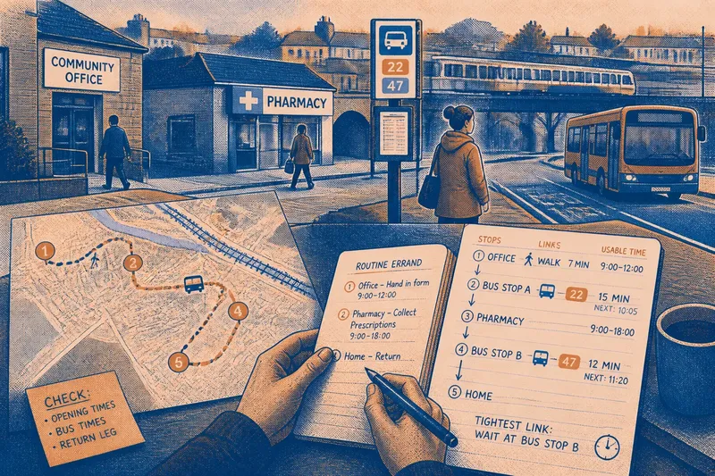
The common mistake is to judge a public service by the straight line between home and its front door. That can make a nearby clinic, library or benefits office look easy to reach, while the real trip involves a long wait, a missed connection or another stop across town. To understand why a service can feel farther away than the map suggests, map the journey as a sequence of tasks and links, not a single distance.
What makes a nearby service feel distant?
Distance on a map describes location. A resident experiences the time and effort needed to reach the service when it is available and complete the errand. Those are different things.
Opening patterns are one source of friction. A service may be close but open only during a narrow part of the day, or appointments may be offered at times that do not fit a bus timetable or a work shift. A journey planned around the door’s location can fail if the door is shut when the resident arrives.
Connections matter too. A route with a change between bus and train, or a walk between separate stops, brings extra waiting and more chances for one delay to affect the rest. A direct route may cover more ground yet feel simpler because it does not require a transfer.
Then there is the shape of the errand. A resident might need to collect a form from one place, provide it at another and visit a pharmacy on the way home. Each stop may be close to the next on a map, but the whole trip has to fit the opening times and transport links of every place involved. Like a set of keys, one missing piece can make the whole routine harder to use.
Which way of mapping the trip suits you?
Choose a mapping method that matches the decision you need to make. A broad route view can expose a location problem; a timetable view can reveal a connection problem; a stop-by-stop view can show where several services turn one errand into a complicated day.
Use a simple route map to compare locations
A paper street map or a standard online map is useful when you are comparing which branch or service point is nearer to home, work or a regular bus stop. Mark the actual entrance, not just the building’s pin, and note any road, river or railway crossing that makes the direct-looking route impractical.
This approach suits a resident choosing between service locations or a local group trying to describe which parts of an area lack a nearby option. It is less useful on its own if the route depends on a bus, an appointment slot or several linked visits.
Use a timetable view to assess connections
Check the relevant bus or rail timetable alongside the service’s opening information. Note when a journey can start, where a transfer happens, and whether there is a return connection after the visit. A route planner can help, but check its suggested stop and service against the operator’s own information.
This suits someone whose main question is whether a service can be reached at a workable time. It also helps distinguish a long ride from a route that is short but has awkward waiting between connections. Do not treat a listed journey as the whole errand: allow for getting to the stop, entering the building and any time spent there.
Use a stop-by-stop trip map for linked errands
Draw each place as a separate stop, then add the link between them: walking, bus, lift from another person or another mode. Beside each stop, write what must happen there and when it can happen. This method suits people who need more than one service for a routine task, including residents coordinating an appointment with paperwork or a collection.
If the right route or opening information depends on a provider’s instructions, the relevant operator or service is the place to confirm it. Local transport arrangements and access to buildings can differ.
How can you map a routine trip without missing a link?
- Name the task. Write down what you need to accomplish, rather than only the service you plan to visit.
- List every stop. Include places where you collect, submit or pick up something, even if the visit seems brief.
- Record the usable time. Note the opening period, appointment time or other point that sets when you can arrive.
- Draw each connection. Mark the walk, route number, transfer or other means of getting from one stop to the next.
- Add the return leg. Check how you can get home after the final stop, not just how to reach the first one.
- Circle the tightest link. Identify the wait, opening window or transfer that could make the rest of the plan impractical.
Say you need to hand in a form at a local office and collect a prescription afterwards. Imagine the office is near a bus stop, but the pharmacy is a separate stop and the bus back runs on a different pattern. On your map, write the office’s usable visit time, the walk to the pharmacy and the return connection. The visible result is a trip plan that shows whether the two tasks fit together, rather than assuming that proximity makes them one easy errand.
What should you do when the route and the schedule disagree?
First decide which part of the trip is fixed. An appointment may have little flexibility, while a pharmacy visit or document collection may be movable. Put the fixed stop on the map, then see whether the other tasks can be placed around it without relying on a connection that is too tight.
If the sequence does not work, compare realistic alternatives: another service location, a different appointment time, a direct route, or splitting the errand across separate days. Each option shifts the burden differently. A more distant branch may have a simpler connection; a closer one may suit a resident who can walk but not travel at the available bus times.
For a local decision, describe the barrier precisely. “The service is far away” can mean a long walk, a transfer that adds waiting, an opening period that conflicts with transport, or several stops that cannot be joined in one outing. Naming the broken link gives residents and service providers a clearer basis for discussing what might help.
Which mapping approach should you choose?
Use a route map when location is the question. Use a timetable view when the journey depends on scheduled transport. Use a stop-by-stop map when one task requires several places. If your routine trip has all three, start with the stops and then add the route and times; that order keeps the purpose of the journey visible.
A service’s real reach is the journey a resident can actually complete, not simply the space between two map points. Keep your trip map beside the information you rely on, and update the part that changes: a service time, a connection or a required stop. That small record can turn a vague sense of distance into a practical question about which link needs attention.